Barn Record Harwinton
RETURN TO ‘FIND BARNS’
- Overview
-
Designations
Historic Significance
Architectural description:
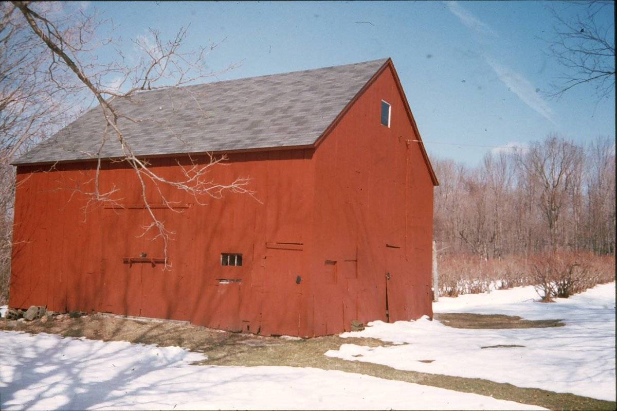
This is a 1 ½-story gable-roofed three-bay English barn, 24’ x 32’. The ridge-line is oriented east-west, and the main entry is a tall door opening in the center bay of the south eave-side.
Exterior:
The pair of sliding doors in the main door opening is new, installed by the current owners since 2010. The south eave-side also has a hinged pass-through door in the east corner, accessing the livestock stalls in the east bay.
The east gable-end has a similar pass-through door at the center, flanked by a shuttered stable window opening on each side. There is a square attic window in the upper part of the gable-end. The north eave-side has one two-pane window set high in the wall of the center bay. The sash is a new replacement in an existing opening. The west gable-end has no openings.
Siding is vertical boards painted red; there is not a distinct siding divide on the gable-ends, although there is a pattern of joints at the location of the interior tie-girt where boards are nailed to the horizontal timber. The roof has no overhang on the gable-ends and a very slight overhang on the eaves. The foundation is un-mortared fieldstone; a few courses are visible at the west end where the grade slopes down slightly. The barn has a wood plank floor supported by floor joists supported a few inches above grade.Interior:
The interior is a hand hewn square rule post and beam frame. The typical bents have a single interior post, slightly dropped tie-girts, and canted queen posts supporting canted purling plates at the mid-span of the common rafters. The queen posts are diagonally braced to the tie-girts near the outer ends. The rafters are hand hewn and appear to be mortised into the heavy purling plates. At the ridge, the rafters meet, apparently in a butt joint, without a ridge-pole.
The center and west bays are open full-height. The east bay has a loft floor beneath which there are stalls for livestock. A low partition along the inner face of the bay is faced with wide horizontal boards, on which there are inscribed initials “EEH CLA” which appear to be old. On the outer face of this partition there are manger compartments, leaving an unusually small area for the animals.Historical significance:
The oldest barns still found in the state are called the “English Barn,” “side-entry barn,” “eave entry,” or a 30 x 40. They are simple buildings with rectangular plan, pitched gable roof, and a door or doors located on one or both of the eave sides of the building based on the grain warehouses of the English colonists’ homeland. The name “30 by 40” originates from its size (in feet), which was large enough for 1 family and could service about 100 acres. The multi-purpose use of the English barn is reflected by the building’s construction in three distinct bays - one for each use. The middle bay was used for threshing, which is separating the seed from the stalk in wheat and oat by beating the stalks with a flail. The flanking bays would be for animals and hay storage.
This barn is significant as an intact example of an early 19th-century English barn associated with an extant house of the Colonial period. The construction details of the canted queen posts and mortised rafters are excellent and well-preserved instances of typical detailing. The identification of the property with a locally prominent citizen adds significance to the site and structures.
Field Notes
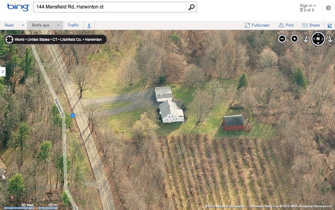
Listed on the State Register of Historic Places 11/06/2013. 144 Mansfield Road. At one time owned by David Mansfield who was probate Judge for many years. In 1997 owned by Phyllis Arsego and R. Perkins. Now a family farm raising blueberries - pick-your-own.
- Use & Accessibility
Use (Historic)
Use (Present)
Exterior Visible from Public Road?
Yes
Demolished
n/a
Location Integrity
Unknown
- Environment
Related features
Environment features
Relationship to surroundings
This farmstead is located in the western part of Harwinton, just north of the historical village of Campville and on a hilltop facing west. To the west the 77.74-acre site slopes down to the right-of-way of Connecticut Route 8, and the Naugatuck River. At this point the river is to the west of the road, which is a limited access highway. Some fragments of an earlier route remain along the river bank.
The farmstead includes a 28’ x 35’ 1 ½-story cape style house dating from c. 1770. The house has its ridge-line oriented north-south and its entry in the center of a five-bay east eave-side facing the road. Its post-and-beam framing can be seen in the attic (where hewn rafters are mortised into a hewn ridge-pole) and cellar (where the hand hewn girders and floor joists contrast with an area of newer framing where the central chimney mass has been removed). The house has aluminum siding and an asphalt shingle roof.A small English barn is located west and slightly north of the house. To the south and west of the barn are fieldstone walls which appear to frame a farm road leading westward and downslope into an area of the site that is now wooded. Historic aerial photography from 1934 indicates that the pasture land extended further down the hill toward the west.
The area today is mostly wooded, with an open area of several acres surrounding the house and barn. A large blueberry patch north of the buildings was established some years ago and has been rehabilitated by the current owners, who are operating a “pick-your-own” berry farm in season.
The property is situated near the western border of Harwinton, approximately four miles southwest of the Litchfield-South Roads National Register Historic District, a collection of 56 historic resources dating to between 1790 and c.1940, and located along Burlington, Harwinton Heights, Litchfield, North, and South Roads at the historic town center.
- Typology & Materials
-
Building Typology
Materials
Structural System
Roof materials
Roof type
Approximate Dimensions
n/a
- Source
-
Date Compiled
02/11/2011
Compiled By
Charlotte Hitchcock, reviewed by CT Trust
Sources
Photographs and field notes by Beverly Mosher, Curator at the Harwinton Historical Society, 2/11/2011; Charlotte Hitchcock 12/11/2012.
Interview with Brooke Cheney, 12/11/2012, at the site.Map resources:
Town of Harwinton Assessor’s Records http://data.visionappraisal.com/HarwintonCT/search.asp .Aerial views from:
http://maps.google.com/ and http://www.bing.com/maps/ accessed 12/16/2012.Historical aerial photography and maps accessed at UConn MAGIC:
http://magic.lib.uconn.edu/mash_up/1934.html
http://magic.lib.uconn.edu/historical_maps_connecticut_towns.html
Beers, F.W., Atlas of Litchfield County, F.W. Beers & Co., 1874.USGS Historical Maps accessed 6/22/2012 at http://historical.mytopo.com/ .
UTM coordinates: http://itouchmap.com/latlong.html .
Print and internet resources:
Carley, Rachel, Litchfield: the Making of a New England Town, Litchfield Historical Society, 2011. pp.241-2.Cunningham, Jan, Connecticut’s Agricultural Heritage: an Architectural and Historical Overview, Connecticut Trust for Historic Preservation & State Historic Preservation Office, 2012.
Connecticut roads web site: http://kurumi.com/roads/ct/ct8.html .
Harwinton Historical Society web site: http://harwintonhistory.com/index.html
Sexton, James, PhD; Survey Narrative of the Connecticut Barn, Connecticut Trust for Historic Preservation, Hamden, CT, 2005, http://www.connecticutbarns.org/history.
U.S. Federal Census, accessed at http://persi.heritagequestonline.com/hqoweb/library/do/census/search/basic
Visser, Thomas D., Field Guide to New England Barns & Farm Buildings, University Press of New England, 1997.
- PhotosClick on image to view full file
-