Barn Record Brooklyn
RETURN TO ‘FIND BARNS’- Building Name (Common)
- n/a
- Building Name (Historic)
- n/a
- Address
- 60 Stetson Road, Brooklyn
- Typology

- Overview
-
Designations
n/a
Historic Significance
Architectural description:
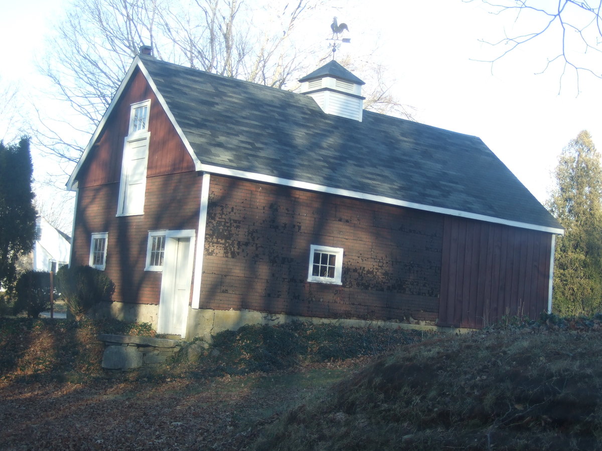
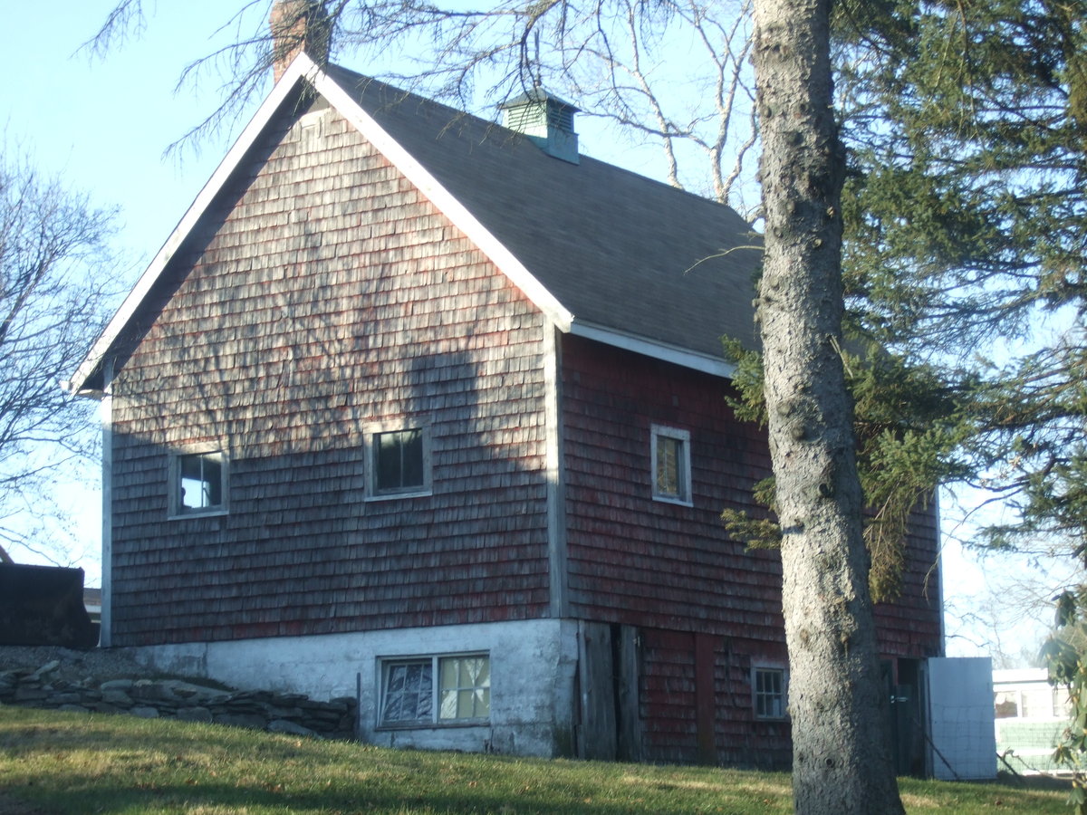
This is a 1 ½ story eave-entry bank barn. The main facade faces south and the ridge-line of the barn is perpendicular to Stetson Road, which runs approximately north-south. The main entry in the south eave-façade is a large board and batten door in the east end, which appears to be a sliding door that has now been boarded shut. There is a fixed six-pane window with white trim in the west bay. The east gable-end reveals a concrete basement with a field stone retaining wall as the ground declines towards the north. There are with two six-pane hopper windows in the basement and a pair of fixed two-pane windows in the lower story. The north eave-side has a pair of exterior swinging hinged doors at each end with a six-pane window in the middle bay in the basement level. One two-pane window is visible in the lower story. The west gable-end has a single interior swinging door at the south end reached by a small fieldstone retaining wall. There are two single six-pane windows with trim in the lower story and a single six-pane window high in the gable end. Directly below this window there is a single door which straddles the loft and first story levels. There is a square ventilator with a hipped roof and wooden louvers in the center of the roof ridge-line. The barn has wooden shingles which are painted red. The roof has a projecting overhang and is covered with asphalt shingles.
Historical significance:
The oldest barns still found in the state are called the “English Barn,” “side-entry barn,” “eave entry,” or a 30 x 40. They are simple buildings with rectangular plan, pitched gable roof, and a door or doors located on one or both of the eave sides of the building based on the grain warehouses of the English colonists’ homeland. The name “30 by 40” originates from its size (in feet), which was large enough for 1 family and could service about 100 acres. The multi-purpose use of the English barn is reflected by the building’s construction in three distinct bays - one for each use. The middle bay was used for threshing, which is separating the seed from the stalk in wheat and oat by beating the stalks with a flail. The flanking bays would be for animals and hay storage.
The 19th century saw the introduction of a basement under the barn to allow for the easy collection and storage of a winter’s worth of manure from the animals sheltered within the building. The bank barn is characterized by the location of its main floor above grade, either through building into a hillside or by raising the building on a foundation.
This innovation, aided by the introduction of windows for light and ventilation, would eventually be joined by the introduction of space to shelter more animals under the main floor of the barn.Field Notes
Gable roofed hay barn.
- Use & Accessibility
Use (Historic)
Use (Present)
Exterior Visible from Public Road?
Yes
Demolished
n/a
Location Integrity
Unknown
- Environment
Related features
Environment features
Relationship to surroundings
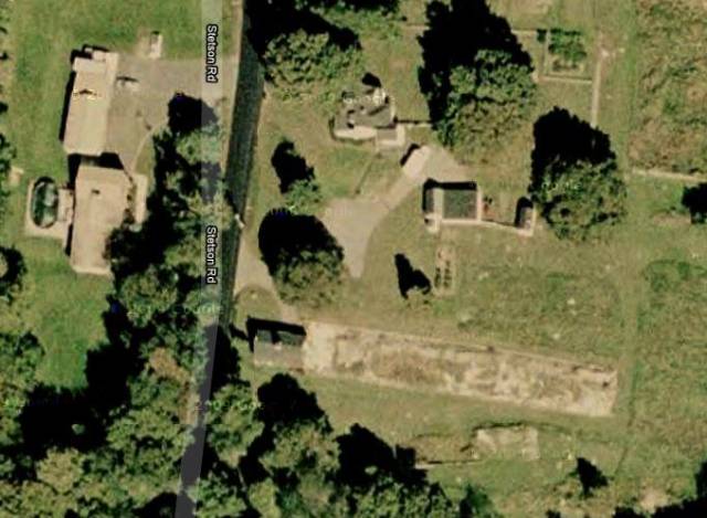
The barn is situated to the south of the house with which it is associated. The ridge-line of the house is perpendicular to the ridge-line of the barn. The house, built in c. 1931, is designed in the Cape Cod style and has a gable and hip roof. A driveway from Stetson Road runs east past the north eave-side of the barn towards two garages and the south gable side of the house. There is a small shed east of the garages. The barn is surrounded by open land, with woodlands on the east of the 74.5-acre lot. The area surrounding the site is woodland, agricultural and residential.
- Typology & Materials
-
Building Typology
Materials
Structural System
Roof materials
Roof type
Approximate Dimensions
n/a
- Source
-
Date Compiled
02/14/2011
Compiled By
L. Mackintosh & T. Levine, reviewed by CT Trust
Sources
Field notes and photographs by Joyce Meader – date 12/22/2010.
Town of Brooklyn Assessor’s Record & GIS Viewer http://data.visionappraisal.com/BrooklynCT/
Parcel ID: 9/ / 15/ /Aerial Mapping:
http://maps.google.com accessed 2/14/2011
http://www.bing.com/maps accessed 2/14/2011.Sexton, James, PhD, Survey Narrative of the Connecticut Barn, Connecticut Trust for Historic Preservation, Hamden, CT, 2005, http://www.connecticutbarns.org/history.
Visser, Thomas D., Field Guide to New England Barns and Farm Buildings, University Press of New England, 1997.
- PhotosClick on image to view full file
-